Elevated wildfire danger expected to return this week as winds, low humidity dry out fuels again
Fire weather setup: wind, dry air and cured vegetation
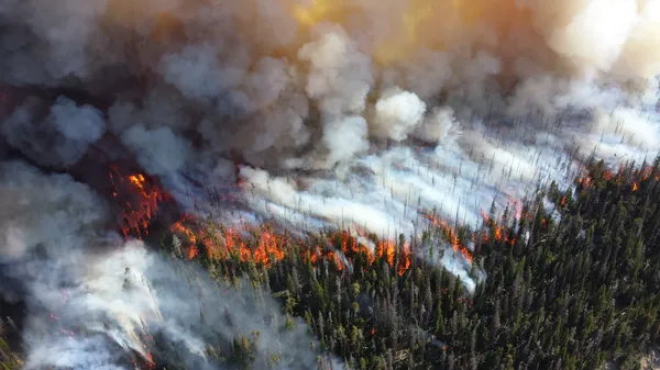
Fire danger is expected to increase again this week across parts of the Southern Plains, including Oklahoma, as a familiar late-winter pattern returns: strong winds overlap with low relative humidity and dry-to-cured grasses. When these factors align, new fires can ignite easily and spread quickly, and existing fires can become harder to control.
Red flag warnings and fire weather watches are issued when meteorological thresholds are met for rapid fire growth. Criteria vary by local forecast office, but the underlying drivers are consistent: gusty winds, low humidity, and receptive fuels. In Oklahoma and neighboring states, dormant grasses and brush can provide continuous fuel beds capable of carrying fast-moving fires, especially during warm, windy afternoons.
Why the risk can return quickly after a brief lull
Fire danger can drop temporarily following cooler temperatures, lighter winds, or brief precipitation, but it often rebounds when dry air and strong mixing return. Fine fuels such as grass respond rapidly to changes in weather: they can dry within hours after a humidity drop and wind increase, even if deeper soils remain relatively unchanged.
Recent seasons have also reinforced that high-impact wildfire conditions are not confined to summer. Wind-driven events in the Plains have produced destructive fires outside the traditional peak season, and emergency managers increasingly treat late winter and early spring as a high-risk window when fuels are dormant and frontal systems bring abrupt wind shifts.
What the outlook means for communities and first responders
When elevated or critical fire weather is forecast, local agencies often adjust staffing, stage resources, and restrict or discourage outdoor burning. For residents, the most consequential changes are practical: ignition sources that might be manageable on a calm day can become dangerous under strong gusts, and fires can outrun initial attack in open country.
Outdoor burning: Any spark-producing activity can become high-risk during red flag periods, including debris burning, welding, and equipment use in dry grass.
Travel and visibility: Smoke can rapidly reduce visibility on roadways, especially in wind corridors and near rangeland fires.
Rapid changes: Wind direction shifts with passing fronts can change fire behavior quickly, complicating evacuations and containment lines.
What to watch in daily forecasts
Forecast products that matter most for near-term fire danger include sustained wind and peak gusts, minimum afternoon humidity, and any mention of critically dry fuels. Even without extreme heat, a combination of strong winds and low humidity can be sufficient to elevate risk.
In Plains fire weather, wind often becomes the decisive factor: it accelerates drying, increases spotting, and drives fast rates of spread in grass fuels.
Residents in high-risk areas should monitor local warnings and alerts and be prepared for rapid changes in conditions through midweek, when the overlap of wind and dry air most commonly peaks during the afternoon hours.