Near-record warmth and critical fire weather risk set to open the week across Oklahoma
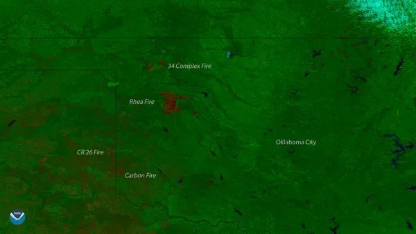
Springlike temperatures arrive alongside heightened wildfire conditions
Oklahoma is entering the new week under an unusual February warm spell that is expected to push daytime highs toward near-record territory in multiple locations. The warmth is arriving at the same time as a fire-weather setup that can rapidly increase grassfire potential, particularly across western Oklahoma and the Panhandle.
The combination driving the risk is straightforward: very dry air, gusty winds and dormant winter vegetation. In this pattern, fine fuels such as cured grasses can ignite easily and spread quickly when winds increase during the warmest part of the day.
What “critical” fire weather means in practice
Fire-weather alerts are based on forecasts that certain thresholds will occur together for several hours. In the southern Plains, that typically involves low relative humidity, sustained winds or frequent gusts, and sufficiently dry fuels. When those ingredients align, fire agencies can expect fast-moving grassfires, difficult initial attack conditions and rapid changes in fire behavior as winds fluctuate.
When warm temperatures coincide with low humidity and strong winds, any new fire start can spread quickly in open grasslands.
Where the risk is highest
The greatest concern early in the week is focused in the state’s west and northwest, including the Panhandle, where wind and humidity frequently align most sharply under downslope and dryline-influenced patterns. Central and eastern Oklahoma can also see elevated risk when winds remain strong and humidity drops during afternoon mixing.
Western Oklahoma and the Panhandle: most likely to see the lowest humidity and strongest winds at peak heating.
Northwest Oklahoma: typically sensitive to rapid fire spread in rangeland and cured grasses.
Central and eastern Oklahoma: may experience elevated danger if winds remain gusty and fuels stay dry.
Why February warmth can increase fire danger
Unseasonably warm temperatures can accelerate drying of grasses and leaf litter, especially after periods with limited rainfall. Even when mornings begin cool, humidity often falls sharply by afternoon as the boundary layer mixes, creating a short daily window when ignition risk and spread potential rise significantly.
This week’s pattern also highlights a wintertime fire-weather reality for Oklahoma: wildfire risk is not confined to late spring and summer. Dormant vegetation, wind-prone setups and low humidity can produce dangerous conditions even outside the traditional peak season.
Operational impacts and safety considerations
During periods of elevated or critical fire weather, local officials often urge residents to avoid outdoor burning, delay activities that can create sparks, and secure towing chains, equipment and trailer connections. Motorists are typically advised not to park vehicles on dry grass, where hot exhaust components can ignite fuels.
With near-record warmth expected to persist into the early week, conditions will be monitored closely for additional fire-weather watches or warnings. Any meaningful reduction in risk would depend on weaker winds, higher humidity, or widespread wetting rainfall—none of which is guaranteed in the short term.