Red Flag Warning expands across Oklahoma Thursday as wind, low humidity raise wildfire spread risk
Red flag coverage grows as fire weather shifts east
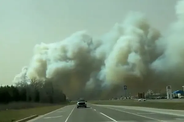
Oklahoma entered another day of heightened wildfire concern Thursday as a Red Flag Warning expanded across most of the state, reflecting a broader footprint of critical fire weather than earlier in the week. The warning period was set to cover daytime hours, when warming temperatures combine with very dry air and gusty winds to create conditions in which any new fire can spread rapidly.
The expansion follows several consecutive days of elevated to critical fire danger across western and central Oklahoma. Fire weather concerns have been driven by a recurring pattern of strong southwest winds, low relative humidity, and dry dormant vegetation typical of late-winter fuels.
What a Red Flag Warning means in practical terms
A Red Flag Warning is issued when the combination of weather and fuel conditions is expected to support rapid fire growth and extreme control difficulty if ignitions occur. In Oklahoma, the warning commonly aligns with forecasts of strong, sustained winds, very low humidity and dry fine fuels such as grasses. These are the ingredients most likely to produce fast-moving grassfires that can outrun initial attack resources.
Thursday timeline: peak risk before a late-day change
Forecast conditions Thursday were expected to keep fire danger elevated through the afternoon, with the risk zone extending farther into the northeastern portion of the state while sparing parts of far southeastern Oklahoma. Wind gusts around 40 mph were possible in the warning area, a threshold that can quickly turn small ignitions into wind-driven fires in open country.
By later Thursday into Friday, a strong cold front was expected to reduce fire danger by lowering temperatures and improving humidity, helping to tamp down the most critical fire-weather setup. While cooler weather typically eases spread potential, officials continue to emphasize that any ignition during the warning window can still threaten homes, infrastructure and responders.
Fire response posture: resources positioned ahead of new starts
With fire activity increasing this week, Oklahoma’s wildland fire response has been operating in a heightened readiness posture. State forestry officials positioned suppression resources and personnel in multiple hubs, including western and central locations, to shorten response times and bolster capacity if multiple fires start at once.
Operational challenges have also been shaped by varying ground conditions. In some areas, recent moisture left soils soft enough to complicate access for heavy equipment, even while grasses and brush remained dry enough to burn intensely.
Public safety actions emphasized during warning hours
- Postpone outdoor burning and avoid activities that can create sparks, including welding and dragging chains.
- Secure trailer safety chains, check tire rims and avoid parking vehicles on dry grass.
- Report smoke or fire immediately by calling 911 and follow local emergency instructions.
When winds strengthen and humidity drops, fire spread can accelerate quickly, limiting the time available for evacuation and initial containment.
Officials cautioned that the most effective wildfire prevention during red flag conditions is reducing human-caused ignitions, which remain a leading driver of winter and early-spring grassfires across the Southern Plains.