Sunny Skies and High Alerts: Critical Fire Danger Hits Oklahoma City
A Bright but Cautious Start to the Weekend
Residents of Oklahoma City are waking up to clear, crisp conditions this Friday, February 20, 2026. While the bright sunshine offers a welcome visual break, the Oklahoma City metro area is facing a dual-threat weather day characterized by freezing morning temperatures and a significant fire weather alert that will remain in effect throughout the afternoon. Local officials are urging caution as unseasonably dry conditions combine with gusty winds to create a hazardous environment for any outdoor activities involving sparks or flames.
Morning: A Chilly, Clear Outlook
The morning hours are starting off quite cold, with temperatures hovering near the 28°F to 30°F mark. Despite the freezing start, the sky remains almost entirely cloudless, providing excellent visibility for the morning commute. Humidity levels are currently at their highest for the day, around 55%, though this moisture will quickly evaporate as the sun rises. There is no significant threat of precipitation this morning, with the chance of rain or snow remaining below 5%. Those heading out early should plan for frost on windshields and ensure they are dressed in heavy layers to combat the sub-freezing start.
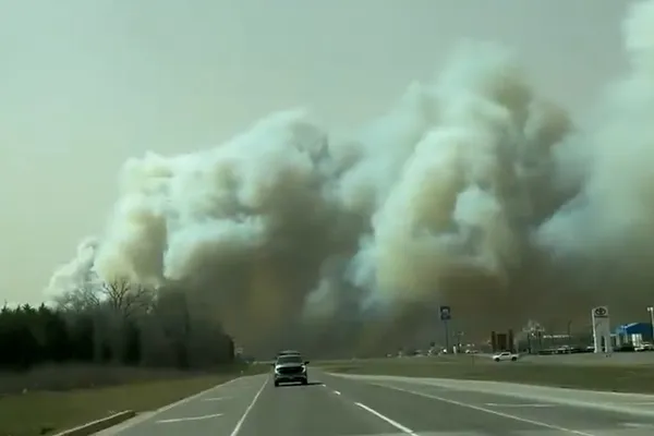
Afternoon: Peak Warmth and Critical Fire Warnings
By the afternoon, Oklahoma City will see temperatures climb to a high of approximately 51°F. While these temperatures are typical for late February, the primary concern for meteorologists is the rapidly dropping relative humidity, which is expected to bottom out near 39%. The National Weather Service has maintained a critical fire weather warning for the Southern Plains, including the Oklahoma City metro, for today. This alert is driven by the combination of dry vegetation, low humidity, and persistent gusty winds.
With a state of emergency already in place for parts of the state due to ongoing wildfires in the panhandle, local authorities are strictly advising against any outdoor burning. The gusty winds expected this afternoon could allow even a small spark to spread rapidly across dormant winter grasses. Residents are encouraged to:
- Avoid any outdoor debris burning or use of fire pits.
- Ensure trailer chains are not dragging on the pavement to avoid sparks.
- Properly discard all smoking materials in fire-proof containers.
- Report any sign of smoke immediately to emergency services.
Evening: A Sharp Cooling Trend
As the sun sets this evening, the clear skies will remain, leading to a rapid drop in temperatures. Expect the thermometer to fall back into the mid-30s shortly after dusk, eventually reaching a low of 28°F overnight. The winds are expected to diminish slightly after dark, providing some relief from the critical fire conditions, but the air will remain very dry. The humidity will stay low, and the clear conditions will persist into Saturday, setting the stage for a calm but cold weekend ahead.