Sky 5 aerial video documents tornado damage near Fairview as Oklahoma begins March 2026 storm cycle
Aerial survey captures the immediate aftermath
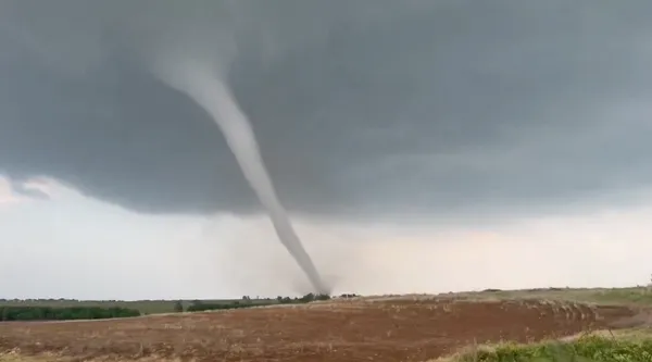
A Sky 5 helicopter flight documented a swath of tornado damage in northwest Oklahoma near Fairview as daylight returned after severe storms moved through the region. The aerial video shows scattered structural damage and debris fields across open country, consistent with a tornado track that crossed rural areas west of Fairview in Major County.
Emergency officials confirmed two deaths in Major County after a vehicle was struck during the storm on the night of March 5, 2026. The crash site was reported along U.S. Highway 60 west of Fairview, where severe weather warnings were in effect as thunderstorms intensified across western Oklahoma.
What is known about the storm and where it hit
The tornado occurred during a multi-state severe weather outbreak that brought large hail, damaging winds, and tornado threats across parts of the Plains and Midwest. Forecast guidance leading into March 5–6 highlighted Oklahoma as part of the corridor where the strongest storms were expected to develop.
State emergency management officials reported multiple preliminary tornado tracks in Oklahoma from March 6 storms, separate from the March 5 event near Fairview. Search-and-rescue resources were deployed to assist communities affected in other parts of the state as the system progressed eastward.
Damage assessment and the EF-scale process
National Weather Service survey teams evaluate tornado intensity using the Enhanced Fujita (EF) scale, which is based on damage indicators and the quality of construction, rather than solely on radar appearance. For the Fairview-area tornado, subsequent survey findings rated the tornado at EF-2 based on observed damage. EF-2 damage corresponds to wind estimates generally capable of tearing roofs from well-built homes, snapping or uprooting large trees, and shifting or overturning vehicles, depending on exposure and impact.
What the Sky 5 video shows—and what it cannot
Aerial video is particularly useful for:
- mapping the continuity of a damage path across fields, roads, and shelterbelts,
- identifying clusters of structural impacts that may guide ground crews, and
- supporting damage documentation for local response and recovery planning.
However, aerial imagery alone does not determine an EF rating. Survey teams must verify damage details on the ground, including building anchoring, construction type, and the directionality of debris patterns.
Public safety context as severe weather season ramps up
The early March tornado near Fairview arrived as Oklahoma entered its spring severe weather period, when warm, moist air collides with strong upper-level systems capable of producing rotating thunderstorms. Officials continued to urge residents statewide to monitor warnings, maintain multiple methods to receive alerts overnight, and identify shelter options in advance—especially in rural areas where storms can move quickly and damage paths may be narrow but intense.
If you have damage information from the Fairview-area storm, local emergency managers typically request reports to help prioritize response and support later assessments.

Oklahoma governor’s call to end medical marijuana raises questions about costs, patients, and state revenues